
Doushantuo Fm
Type Locality and Naming
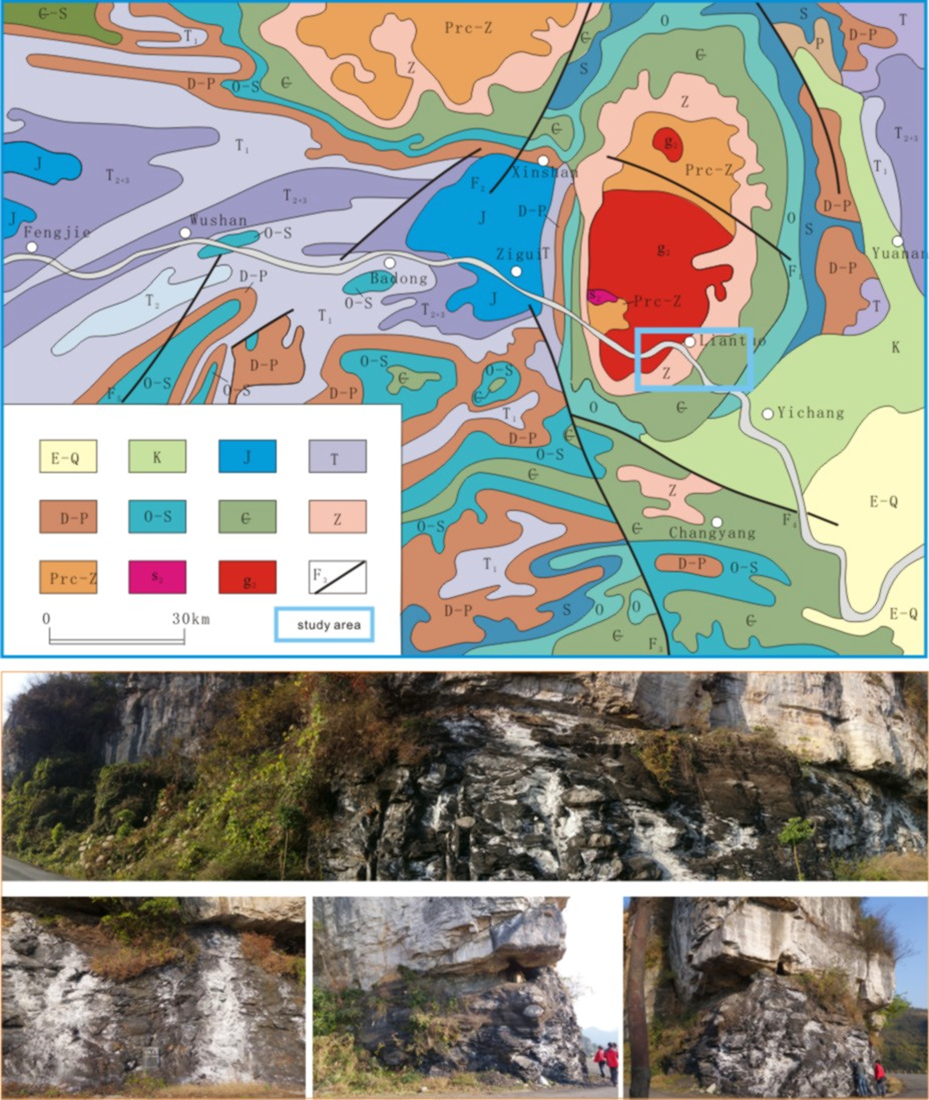
The Doushantuo Fm was named by Li Siguang (Q. S. Lee) and Zhao Yazeng (Y. T. Chao) in 1924. The naming locality Doushantuo is west of the Liantuo Town; the typical section is located east of the Liantuo Bridge and the reference section is in Tianjiayuanzi of Liantuo area, Yichang County, Hubei Province, which was re-measured in 1988 by Zhao Ziqiang, Xing Yusheng and Ding Qixiu.
[Figure: The geological map of the Eastern Hubei Province and the Doushantuo Formation (photos by Kuang Hongwei, 2017)]
Synonym: (陡山沱组) , Toushantuo Fm, Tooushantou Series; Fuziya limestone Fm (Hubei), Tanping shale Fm (Jiangxi), Tonglingqiao Fm (Zhejiang), Lantian Fm, Huangxu Fm (Jiangsu, Anhui), Yangshui Fm, Songlin Fm (Guizhou), Guanyinya Fm, Lunasi Fm, Wangjiawan Fm, Nazhang Fm (Dian), Doudi Mountain Gr (Henan), Shangjiadian Fm (Hubei), etc.
Lithology and Thickness
The Doushantuo Fm is mainly gray, brown, and gray-white dolomite dominated by gray, dark gray and dark argillaceous dolomite. The dolomite in the lower part contains a lot of cherty and phosphate nodules and lumps, which have micro-beddings. The middle part is gray-black sheet-like silty dolomite. In the upper part, the dolomite is usually intercalated with cherty bandings and lumps. In west Hubei and central to east Guizhou, the Doushantuo Formation contains phosphorite, and the black shale includes silver, which locally forms an ore. The total thickness varies from 100 to 200 m, locally only several tens of meters. It is 50-491 meters thick in Yangtze area, and 317-1387 meters thick in the southern Qinling-Dabie Mountains.
Relationships and Distribution
Lower contact
Usually intercalated with a bed of manganiferous dolomitic limestone at the base ("cap carbonate"), which contacts with the grayish green clay boulder of the underlying tillite of the Nantuo Fm. In Sichuan province, it’s in conformable contact with the underlying Mingyue Fm.
Upper contact
The top, a bed of black carbonaceous shale, is bounded by the dolomite of the overlying Dengying Fm.
Regional extent
It widely distributed in the Yangtze stratigraphic region, including Yichang Three Gorges area of Hubei province, Hunan, Guizhou, Guangxi, northwest Jiangxi, northeast Anhui, east Yunnan, north Shaanxi, northeast Sichuan Province, etc. Note that: In Fujian Province, the original Doushantuo Formation is not the Doushantuo Formation (actually the Nanyan Formation).
GeoJSON
Fossils
It has abundant fossils such as microplants, macroscopic fossil algae and metazoan. The microplants include more than 20 genera, including some acanthomorphida such as Micrhystridium, Comasphaeridium, Tianzhushania etc. The macroscopic fossil algae include: Enteromorphites, Doushantuophyton etc., vermes: Sabellidites, and sponge spicules: Eospicula yichangensis, Hazelia liantuoensis etc.
Age
Depositional setting
The onset of the Doushantuo Formation is the outcome of the marine transgression caused by the melted glaciation of the Nantuo stage. In that time, most parts of the Yangtze old land drowned by the transgression to different water depth. In the naming area of the Yangtze Gorges, the Doushantuo Formation probably belongs to the extremity of the carbonate platform slope and the sea bottom was probably situated under the wave base, which was near the depth of the shelf of open sea.
Additional Information